Andrej Mertelj, CEO of Datalab®, coordinator AgroIT Consortia, Ljubljana/Slovenia, Andrej.Mertelj@Datalab.eu and Dipl.Ing. Walter H. MAYER, Founder Club of Ossiach: CEO, PROGIS® GmbH, Villach/Austria, mayer@progis.com
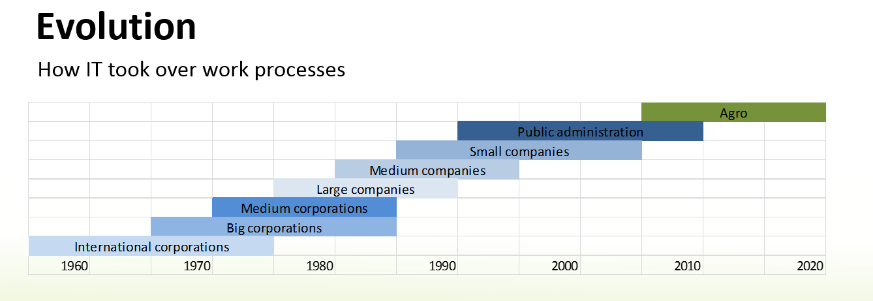
As we have seen during the last years lots of new technologies showing up, the key questions like (1) precise technology assessment, (2) the integration of the different technologies and (3) the necessary stakeholder cooperation has not been done. Further (4) the question around public and private needs had been not taken into consideration, every side worked more or less alone according their – in many cases legally defined targets. When we speak about the great natural models like “Location based circular flow management” or the natural model to work without waste, we, with our human models are far away. Already the fragmenting of the nature in agriculture, forestry, water management, environment etc. is obvious as the nature is an integrated model and does NOT work like that. Closest to such a model is the farmer, he has in many cases to understand and to work within all the different sectors.
We’re using three examples on needed cooperation: geo-based holistics; open read/write registers, multi-stakeholder syncrhonisation and as conclusion raise the importance of shared data policies.
KEYWORDS: ICT, ERP, FMM – farm management, GIS, FMIS, nutrient- and carbon balance, logistics, precision farming, inclusive agriculture, stakeholder cooperation, forestry, land consolidation, animal module, wine-yard module
Why?
Worldwide we grow 1,5B ha crops, 3,5B ha are used by animals and less than 5B ha are forests. We can estimate an average output at € 500,–/ha/year. This total value of approx. 5 T€ in agro-turnover or 40 – 50 T€ in turnover embedding food- and drink industry, wholesale and retail must be managed sustainably and optimized with economic and ecologic targets. Agriculture is not free of charge. Having in mind carrying capacity of the land as welal as the needs of the population, keeping sufficient humus, sustainable forests etc. are tasks of upmost interest for all of us. That in the feedback loop again increases the value of the – better managed – land and with it farmer’s personal and the state assets.
A 10% increase/optimization can be €50 B/year plus better ecological value. ICT has done much more in other areas of human activities. Better managed land will have not only a better output, economic and ecologic, but also a better price/ha – we increase the farmers assets but also the assets of whole countries.
How and who?
What is needed to succeed in agriculture, to increase food and feed, improve and be sustainable?
Let’s learn from the history. Elinor Ostrom got 2009 the Nobel-prize for business science evaluating this question. Best results were found in native tribes in virgin forests (Africa, South-America) and at Swiss farmer´s cooperatives. She worked out rules defining a successful and sustainable community: (i) Precise defined borders, (ii) congruence between rules of acquisition & allocation, (iii) local requirements, (iv) organizational structures for collective decisions, (v) control & penalty, (vi) conflict solving mechanisms and (vii) a minimum organization structure. Cooperatives of today have similar rules but need to be structured to “human” sizes!
We firmly believe that we should apply similar rules between the stakeholders/beneficiaries in the process of ICT-implementation in agriculture.
The beneficiaries: In general – much of the information prepared by the agricultural ICT backbone can be used by several stakeholders and will be a benefit for several businesses. It means chain-partners will be ready to pay to get access to the information! The model in detail has to be worked out together with local structures and representatives from different stakeholders! A public-private used ICT infrastructure, consisting of new ortho-images for the country covering GIS and IT solutions for rural area management in connection with land-management and extension-services, agriculture management and logistics can be used by different governmental organizations and can also be used by private structures and is:
- Supporting farmers to give them tools for bettering economic calculations, better access to markets, gets new service business in environment etc.
- Growers/purchase & sell/machine/… cooperatives can profit greatly from the simplified information exchange and a quantum leap in organizational /operational support.
- Supporting food chain partners: traceability, documentation
- Supporting logistic services to do right actions at the right field to find the right roads, be there at the right time and deliver goods to the food industry “just in time” is a support to all suppliers and buyers of farm goods
- Supporting consultants in their advisory work (data driven decisions, reduction of data acquisition times) and supporting the academy to create better science
- Supporting the Minister of Agriculture for his needs to organize subsidies but also to support and define rules for the management and control for the so called “Commons” with lots of new jobs for farmers,
- Supporting the Ministry for landscape changes, cadaster, ground tax
- Supporting the agro control organization for subsidies
- Supporting bankers – business-plans enabling financing farmers on ROI
- Supporting insurance companies to do the right policies for the right produce
- A great opportunity for the ag machine vendors for the break-trough in precision farming adoption
- Supporting the ecology expert or also the natural-risk-manager for the appraisal of the risks related with field or ecological coherences
- Supporting human medicine experts to judge the influence of the activity of the farmers (food and environment) towards the whole population
What exactly?
Looking at the above list of beneficiaries and stakeholders from an ICT point of view, it’s quite evident, where the connections are:
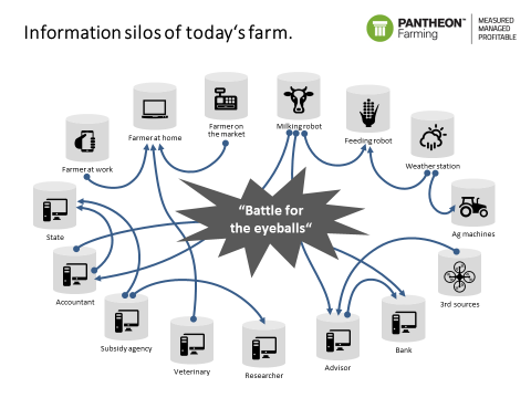
We have to come from the information silos of the single farms and public entities of today to an
- integrated Agro-IT model of the farms of the future that support
- the private food/feed industry,
- gets closer contact to the consumers that will be in return the driving force for quality and
- is also better integrated into the “management of the commons” and the related needs.
We see that the information is kept in silos in the narrow-scope applications with little attention given to the world outside this narrow scope. Those silos are in constant battle with each other for farmer’s attention: how much of his precious time should farmer devote to Ag machine data vs. Meteo data? How much does he need to sit in the office preparing papers for either accountant or state subsidy? Did I forget to put my milking robot app on “Notify”?
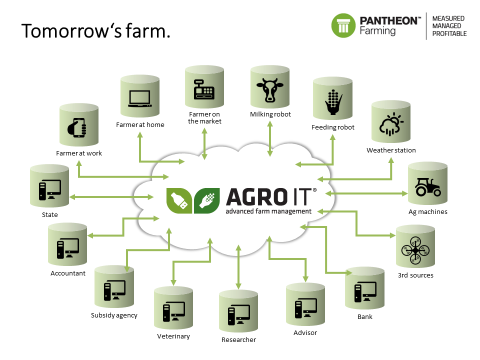
That’s why we’ve created integrated Agro-IT….
Now let’s go into some specifics on why you can’t go alone in connecting those islands. Let’s first look at geo:
#1: The importance of geo-location or 10 steps towards the target
Everything what we plan or do in agriculture is related to the land, to a specific location. We have to take into consideration that maps are an important element to understand our farm or even our land better. When starting to manage a farm we need maps, we can buy them or get access via a public or private service.
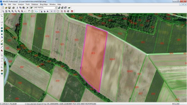
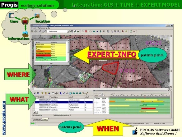
Pic 1: WinGIS with orthoimage, LPIS and farmers database as local Pic 2: Farm management with DokuPlant® integrating GIS, time
application or used via WMS services for fast, countrywide coverage management, expert information and applications for economic and
and carrier of many powerful applications: for crops, forests, animals, ecologic management (costs, nutrients, carbon, insurance, subsidies,
logistics and transport, traceability, land-consolidation, … thematic maps etc.)
As the government also needs maps it would be a good idea to use their maps for both sides, public and private. Today we play a game like children – I do not want that you play with my toys. So to optimize a system within a country, a first step would be the evaluation of existing public and private structures and the information flow within/across detected gaps and future needs of information within the sectors.
The second question will be the setup of the ICT backbone of orthoimages and weather- and soil-sensor-station and the access for everybody to such data. We need for the future a combination of top-down and bottom-up models –internet works in both directions!! – to support all stakeholders with this infrastructure. The quality, quantity, costs and returns and the existing structures have to be evaluated and integrated. The production of high resolution ortho-images, access-able by ALL stakeholders (Microsoft with its Bing® Maps throughout the EU and US with 30cm resolution, done in 30 months and EC certified showed what is possible if wanted. Some countries answered with “we need 25cm resolution” to keep their monopoles upright!) for the entire country as base for any planning and control, not limited to a.m. sectors, to build-up an online mapping service is a must.
Preparation of LPIS (Land Parcel Information System) is the third mission done with GIS support, ready in the most EC countries, not available with sufficient data in many other regions of the world.
As next the fourth step, the farm- and or forest-management has to be set in place taking into account the needs of different users next to farmers/foresters. Some of them will be able to run it alone, some of them will need help and support = advise. A new possibility shows up for advisory services, independent if public or private. They will work as service providers for the stakeholder group within a region, using state of the art technology. With such a model, country coverage can be established fast. Beside advisory services also large farms or even food-industries can guide this service process as everybody will benefit of it. If once a model is established, WHERE, WHAT and WHEN an activity has to be done – an enlarged GIS application is needed – the advisor/service provider will support this process from distributing seeds or fertilizers till the use of machines and does business calculation, nutrient and/or carbon balances, cost calculation, subsidy management or even business plans, supporting insurance companies and also maps. The data come from expert models done together with local experts.
Systems must have in future beside the integration of maps also integrated expert data with all relevant agricultural data and cultivation recommendations supported by local expert partners and a perpetual planning and documentation tool. With this FMIS tools, extension officers are enabled to plan and control every field with a click, for a farm, a region or a whole country. Following information will be generated from every field and can be accumulated for the whole country: activity management, crop rotation, cost calculation, nutrient balance for N, P, K, Ca, Mg or more, carbon balance (models are ready to support carbon balances for complete countries to enable carbon financing for complete countries based on measurable indicators) and if needed energy balance, input/resource needs, harvests.
The GIS, real-time management and expert-data base are fully integrated within the FMIS database application. The mapping of plots/fields is supported and a perpetual calendar enables the display of any performed activity: what – when – where. The integrated database is filled with agro expert data, generated in close cooperation with local agro-forest-environmental scientists/experts (our e.g. German expert models contain 2.500 agro-machine data (KTBL, costs, time, …), data on thousands mineral-/organic-fertilizers, seeds incl. varieties, 850 pesticides with chemical contents and 400 crops with average yield and seed needs including the prescribed complete working process for a year or a growth-period with all activities and resources needed is predefined for all crops and enables planning with one click: Where (plot in the map) do I plan what (select crop from the expert data bank). Individual farmers can modify the expert data at any time. Similar like in agriculture, a forest-management sytsem has to have integrated an expert model supporting local growth tables of local species; if they are not available, how to setup them can be trained locally.
When the data finally are stored in cooperation with IT providers within an Agro-Trust-Center® – rules have to be defined together with public and private bodies – that stakeholders incl. the farmers are sure that their data are not misused. If we try to split private ownership of land and ownership of the information of this land we start to destroy private ownership of land and our democratic principles that will end in a disaster.
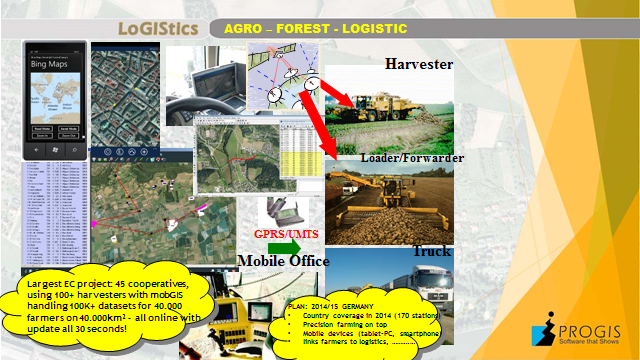
Pic 3: Logistic with dispatch centre, mob-GIS and communication + data transfer
If in a fifth stage, logistics + mobile GIS solutions have to be implemented, all mobile devices from tractor to harvesters can be managed, guided and controlled via a dispatch center. Logistic needs for group of farmers/foresters/industries will be generated on base of accumulated data from FMIS (see above). Process- and time optimizations, where to deliver what” or “where to pick up what and when” and how to come to that location (with the help of the rural Open Street Map (OSM) as well as a just in time delivery from field to industry will be realized. The systems lead to an optimization of daily and seasonal routing, accurate information of harvest status, GPS positioned data visualization, online two-way communication between central and mobile terminals and order processing is supported. The software consists of a GIS central station and any number of mobile units (“mobGIS”), integrating GIS, communication (GPRS/UMTS) and GPS. It handles crops for food/feed or biomass production, liquid manure deposits, forest harvesting or any other logistic task. Up to 30 % cost reductions or more could be achieved. This technology-implementation is to communicate with all mobile devices from a central office and is the precondition for a future Precision Farming (PF) or Precision Forestry implementation.
PF means that we can distribute on existing technology not only a contract where to drive and what to do but also a map, a Precision Farming map as step six. The key question will be who is managing these maps? It is a deep agricultural know how necessary. Not the machine is intelligent, it is the map that brings the know-how to the machines and we need information: Soil analysis with GPS, previous-, following and in-between-crop, crop residues on the field with their chemical content, satellite information regarding chlorophyll content etc. With this inputs agro-experts are able to create fertilizer maps and/or pesticide maps for site specific management.
When we really want to do Precise Farming in a manner, the nature tells us, we have to come step by step closer to a “Location based circular flow management®” that integrates the know-how of the contents of the (1) feed – not every kg more brings more milk or meat, maybe just more manure with higher N-concentration that due to a bad fermentation stinks – (2) manure or liquid manure if available and (3) soil with GPS coordinates linked. Only if we are able to do this precise we will be able to speak about precision farming. Near Infrared equipped labs with the needed calibration methods to get excellent and cheap results are the fundament of it. Technology is here just all the elements have to be linked together.
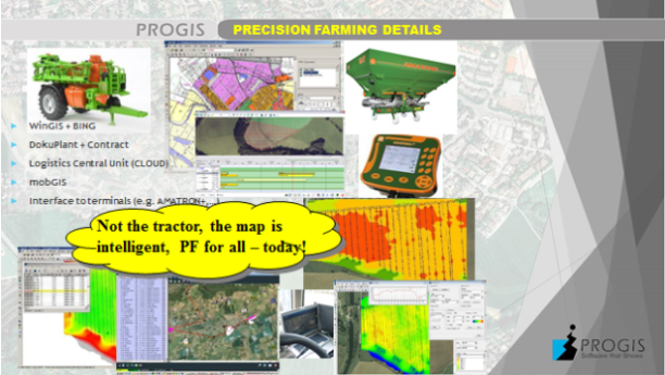

Pic 4: Precision farming: Expert know how supported by ICT-tools Pic 5: Circular flow management: feed-manure-soil plus NIR-labs
If wanted the following seventh step can be implemented: Virtual farming®, the optimization of fields with neighbors together. Create larger, better shaped fields and split with calculation models verified costs and revenues per m² according PF-documentation of activities (=costs) and harvest results (=returns) to increase profits.
Groups of farmers in a region or in a country can also optimize the environment within a step eight from changing quantity/quality of water, creating nice landscapes, do bioenergy production or carbon buffering till influence local climates or produce recreational areas. These services must be done with social responsibility in mind but knowing that hard work has to be done to offer them. Similar like environment services also natural risk reducing services as step nine can be done by groups of farmers in a region or a country: To buffer more water upstream that less water downstream creates no floods is an agricultural/forest service. To manage all this more, better and accurate, just in time information is needed, the farmers can become the transponders and the experts provide the know-how and setup projects, verify and control the transfer and farmers get paid for their services. The technology available is called EnvirOffice® and has also a local to be defined expert model integrated.
On top of all and as module ten, land consolidation, a job driven by government agencies (in Austria “Agrarbehörde”), can optimize the regional infrastructure (water, roads, landscape etc.) as well as focusing on the optimized situation of the farmer´s fields. A further question stays: “How informatics help integrating farmers/foresters as part of environmental caretaking, supporting also commons?”
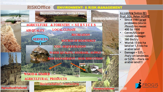

Pic 5: Environmental caretaking and risk management Pic 6: Land consolidation and managing of commons
are new services to be offered by farmers will help farmers AND all of us!
Everything we talked is developed, must be fine-tuned with the integration of local experts of all sectors and can be implemented on a countrywide level everywhere within 3-5 years. We also know that economies of scale works what means that cooperation in ICT will also work in agriculture or forestry just the technologies needed and the stakeholders involved as well as the combined public AND private interests make it more complex. In other words it needs better and structured cooperation of all stakeholders.
Larger and well educated farm(er)s, farmers associations with all their members or industry related contract farmers can start today; they just have to work together and order – the benefits to be reached – together – will be enormous.
#2 Open, accessible and updateable registers
As we learned above already, we need not only ICT enabled access to cadaster data, to LPIS data or to meteorological weather-data – we have to note that farmers do not need a weather-station but weather information, however this is organized but we have to ask why today several public organizations build up their own weather data network – but we need also for running farm-management systems a database of seeds, of organic and inorganic fertilizer, of pesticides, of machines, of phyto-pharmacy data, growth tables in forestry etc. etc.
The open data initiative from the EC needs to be fully implemented in agriculture and forestry, not only for geo-data but for ALL needed data.
As countries already have much of this information digitized, some allow even web-forms to be filled by humans, the data is mostly there. A proposal however would be to make this registers etc. not only human readable/writable but also machine readable/writable thus enabling the automatisation/integration of business processes. A simple example: the farmer now enters a new cow (change of pastry, sale, …) into his heard management system or accounting system. Then he logs in to government portal and enters the same data again there (or has his agricultural consultant or veterinarian that does the same). Our proposal: the government registers must also have a web-service*, after the cow is entered into the farmer’s system the latter uses farmer’s digital certificate, waits for farmer approval (one click for all herd changes), connects to the government web-service and updates the data. The reduction of the buerocatic burden is massive. What is valid for the animal registration systems is also valid for the subsidy system: A farm management system can integrate a subsidy tools that – when an interface is available at a government portal – the subsidy data automatically can be sent to the government system. Again double data entry is avoided. Rule No 1 in ICT: Never enter data twice! Is this not valid for the agriculture Ministry or payment agency?
#3 Sharing the data for an optimized production chain
Now let’s look at the importance of holistic data analysis and unified standards on a showcase farmer/machine cooperative.
Nowadays a question of resource availability and efficient resource utilization is on agenda of every market-oriented business. In terms of agro-sector, on the one side we have a farmer, who needs a certain set of machinery for production, however cannot afford to have it or cannot utilization levels needed for the return of investment. On the other side, we observe machinery owners who annually experience a machinery value reduction due to amortization and inefficient or little use. Out of this problem, machine cooperatives were born as an intermediator between the two. We firmly believe, that by organizing the all the stakeholders into a digital ecosystem we will see a spike in productivity, equipment utilization, increased ROI for the machine owners/operators and decreased cost for the farmers.
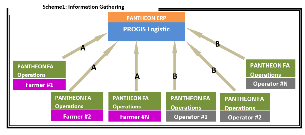
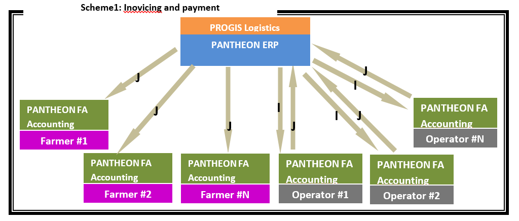
Drafted solution includes two modules – FMIS used by the farmer and Logistic module coupled with the ERP used by cooperatives. The digital information exchange by the stakeholders is drafted.
Organizing process starts with a farmer, who needs to complete standard field operations – such as ploughing, seeding, fertilizing, spraying, harvesting, transporting, storing. In order to keep track of all the tasks and plans we suggest him to use FMIS which derives the information from the planned production cycle. Data containing FieldID, field shape and location, crop type and approximate scheduled task list is derived from this plan and sent electronically to one or more machine cooperatives in the form of Requirement datagram (A).
On the other end, the owners of the machinery submit their data containing machinery type, characteristics, capacity, price and availability in an Availability datagram (B).
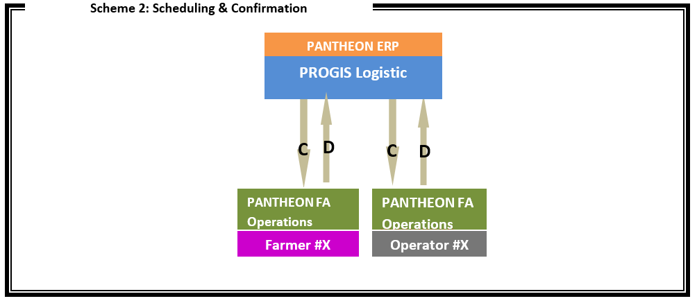
When the schedule is completed in the Logistics module, the Schedule datagram (C) is sent by Machine cooperative to the machine owner/operator. Schedule datagram contains FieldID, Farmer ID, Machine operator ID, field shape, culture, task to be performed, machinery type, price and planned start & end times. Operator responds with Schedule confirmation datagram (D) to the Machine cooperative stating that the schedule is accepted. Receiving the confirmation from the machine owner/operator the Machine cooperative sends Schedule datagram (C ) to the farmer who also responds with Schedule confirmation datagram (D).
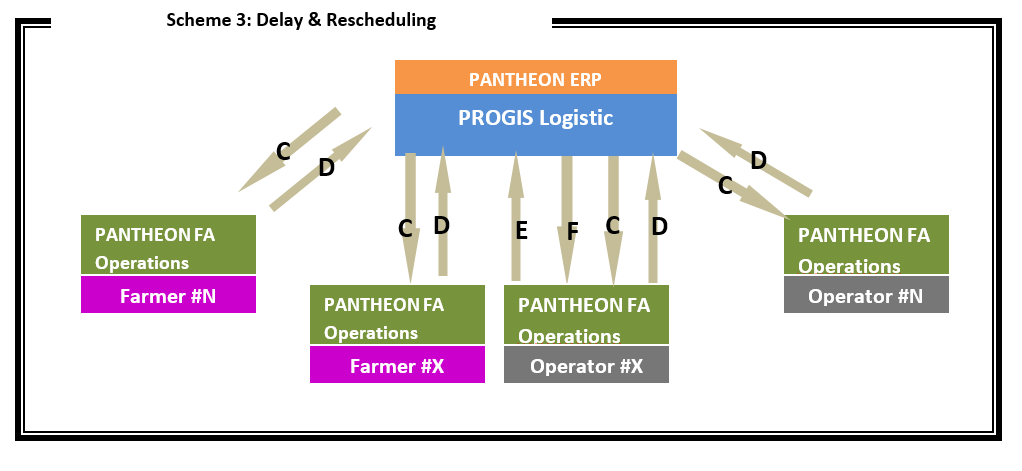
Machine owner/operator sends to Machine cooperative a Delay datagram (E ) stating the Schedule ID, problem description, estimated time to eliminate the delay and information if the farmer will wait or if the Machine cooperative should reschedule him too. In case of rescheduling, Machine cooperative notifies this farmer of a new schedule with Schedule datagram (C ) and farmer responds with Schedule confirmation datagram (D). When the problem is resolved, machine owner/operator responds with Delay resolved datagram (F). Other farmers, using the same machinery downstream also get updated Schedule datagrams (C ) and respond with Schedule confirmation datagrams (D). Based on the confirmations, the delayed owner/operator gets new Schedule datagrams (C ) and responds with Schedule confirmation datagrams (D). Optionaly, Machine cooperative might reschedule also other machine owners/operators to fill-in for the delayed machinery with Schedule datagram (C ) and respond with Schedule confirmation datagrams (D).
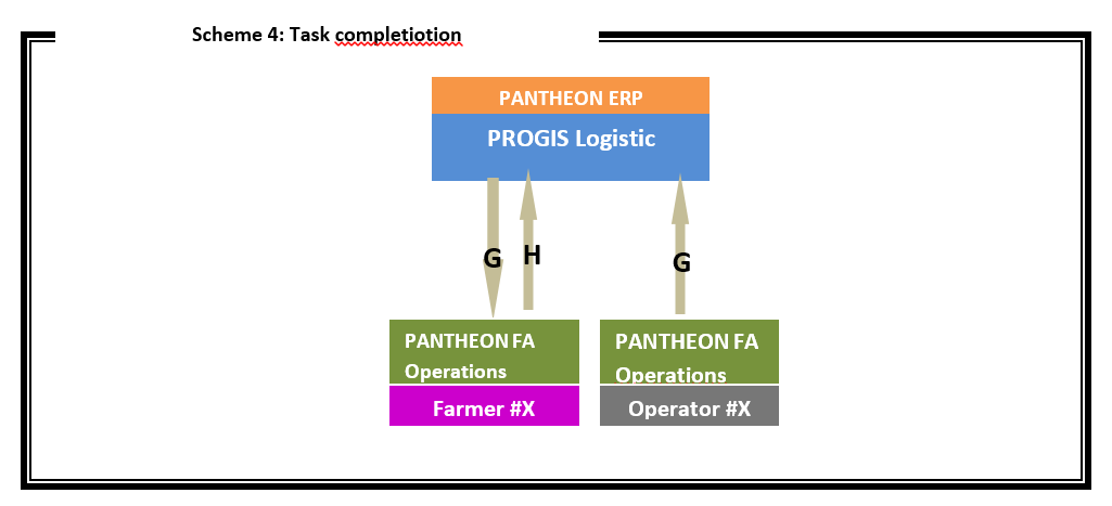
When the schedule is sent and confirmed by both sides, a machinery operator may proceed with the task. After completing, the owner/operator send a task report to Machine cooperative indicating the time and date on the field, task details, names of people involved, workload, machinery characteristics and billable time in a Completed datagram (G). The report is then forwarded to the farmer who confirms the task completed status via his FMIS with a Completion confirmed datagram (H).
ERP at the Machine cooperative takes the data from Logistic module of all the accepted completion reports coming from different machinery operators and issues Invoice requisition datagram (I) to each machinery owner/operator specifying Field IDs worked on, quantity and price. Operator responds with an Invoice datagram (J) – basically an electronic invoice to the Machine cooperative.
Machine cooperative then regroups the accepted completion reports by farmers and issues Invoice datagram (J) to them. As the farmer uses a FMIS, all his invoices will automatically be transferred and stored there. This fact eases the accountancy and financial reporting of the busines Farmers pay the invoices to the Machine cooperative and the Machine cooperative deducts a processing fee for its service and sends the final payment si done to the machine owners/operators.
Proposed solution caters for the data inputs, facilitates efficient resource management trough smart planning, shortens reaction cycles and last but not least – significantly reduces paperwork for all the stakeholders involved. In this paper we explain five practical steps on a way to create a top-end machinery cooperative.
…All this complexity beyond getting tractor coordinates or ISOBus data into the FMIS. Therefore the path of Claas or JohnDeer-e with addressing just one – yet pressing – issue is insufficient. Farming is a very complex business. It should be digitized per partes but a general lookup shall apply. As we have even more pressing discoussions pending:…
#4: Mandatory or opt-in data sharing: a tough question
The farmer’s data belongs to the farmer. Therefore any aggregations, sharing or calculations based on those data can only be a conscious and well informed farmer’s opt-in unless specifically required by the government. End of story.
But part of these data must be shared (eg. in exchange for subsidy, mandatory by law, …) and part of that data makes sense to be shared (like the above sharing between a machine cooperative and the farmer). Data policies needs to be forged based on such guidelines in relation to the farm operational data.
Please let me first try to clarify »personal data«: the aim of AgroIT is solely to get farmer (the individual) access to the data, already collected on the national level. Into this group of »personal« data the following governmental data access should apply: LPIS, cattle and animals register, subsidies, workforce registration, …
We would not aggregate his personal data nor make it accessible to the others. So unlike e.g. Facebook that uses the farmer’s personal data and has access to their profiles thus creating the much needed discussion on personal data, the farming data in question would be stored in a single tenant (farmer) database either on his personal machine or on the cloud. Furthermore we strongly advocate the use of digital certificates (e.g. those from e-banking) to access data only with authentication.
Now the truly synergetic part happens when you combine the two: the production cycle data in farm management cycle notifies the farmer of due spraying, goes with field ID into LPIS and sees the field is in Natura-X. It then goes in the phytopharmacy register and presents the farmer the list of allowed products/chemicals.
Let’s use the above synergetic example and extend it a bit further. If the LPIS is aware, that a beekeeper has placed hives in the very same Natura-2000 area, it can include that information to limit recommended pesticides to the farmer and thus protect the bees. Things to discuss: must the bee-keeper provide this information or should he just have the possibility as it’s in his best interest? Should the location be known, is the farmer obliged to use this information (as it might increase the cost for him)?
Closing statement
Such use-cases and technological possibilities will significantly affect the future of agriculture once we look at the implications beyond the needed data collection on the government level. My firm belief is that a policy agreement of quid-pro-quo needs to be forged where government will open their side of technology while requiring from farmers higher resolution policy-making data (e.g. FADN). Both sides need to work hand in hand towards the common goal. As the history of IT projects teach, one-sided approaches slow the adoption and significantly increase the costs.
Therefore, for the European Union we would suggest a deep cooperation between DG AGRI and DG CONNECT as well as the integration of JRC in Ispra. We need serious thinking regarding the mapping of our agri-policies to the challenges & questions of the approaching digitalization. We need better standardizations, ontologies and expertise of the ICT. There are a lot of unknowns and a lack of the big picture where we want to be.
A main problem today is also the existing structures and their unwillingness of change what from the point of EC even is dangerous as no change means to stay behind or: To setup something new is easier than to change an existing structure. Other countries outside Europe could be faster. That is our European challenge!